Latest News

RADARSAT-2 over Canada’s Gulf of St. Lawrence.
Image courtesy MDA Geospatial Services
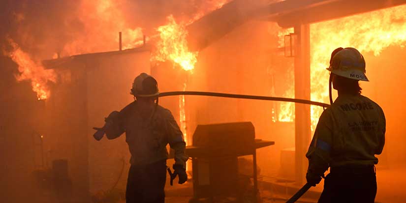
Richmond firm’s satellite images guide disaster relief in flood-ravaged Houston
Published 11:41 PDT, Sat September 2, 2017
Last Updated: 2:12 PDT, Wed May 12, 2021


Have you ever seen an object flitting across the night sky, moving too fast to be a star but too small to be an airplane? That’s likely a satellite on its trip around the earth.
One of those dots in the heavens is RADARSAT-2, a satellite designed, built and operated by Richmond’s MDA Systems Ltd.
This satellite is now playing a critical role in rescue and relief efforts in flood-ravaged Houston, Texas.
Hurricane Harvey flooded great portions of Houston. MDA provides information to the United States’ Federal Emergency Management Agency (FEMA) and other relief agencies so they are able to know exactly what’s changed during a disaster.
Gord Rigby, director of operations for MDA Geospatial Services, says the satellite is able to take extremely high resolution images from 800 kilometres in the sky.
It is roughly like taking a picture of the west coast while standing in Edmonton and being able to see if there’s a big moving truck in front of your house in Richmond. That kind of resolution is useful in a disaster.
“While we can’t see details inside a garage, we can see if the garage is missing.”
MDA’s ground receiving stations and computer facilities do more than just print out pictures from the satellite.
“We have to process the information the satellite gives us,” says Wendy Keyzer, manager for marketing communications for MDA’s Information Systems Group.
The radar data coming back from the satellite is run through specialized computer programs, to turn the raw data into the pictures we see.
MDA is able to create flood maps that gives an accurate measure of the location and the extent of the flooding.
MDA used their computing expertise to overlay the satellite’s data from June 2016, with a flood image taken Friday, Sept. 1 to show what’s changed.
Currently, MDA can track daily changes in Harvey’s damage.
“RADARSAT-2 flies over one or more times a day right now, over the hurricane-affected area in and around Houston,” Rigby says.
While MDA provides RADARSAT images showing the extent of the flooding on a particular day, there’s a lot of data embedded in that one image that relief agencies can use to get even more useful information, such as which highways are flooded on any given day, he says.
The fresh information can help FEMA plan safe escape routes out of and safe aid routes into the area as the disaster, and then clean-up, progress.
While MDA has a direct contract with FEMA, the aerospace firm also provides data-filled satellite images for disasters around the world through the Canadian Space Agency (CSA)
“The CSA is part of the Disaster Charter, an international agreement between countries to help each other,” Keyzer says.
MDA is currently providing help with another disaster, one that’s receiving little media coverage.
“As a result of a lot of monsoonal flooding in south east Asia, we (are tasking) the satellite in response to urgent requirements and deliver images in a quick fashion,” she says.
More than 1,000 people have already died in India, Bangladesh and Nepal’s ongoing floods.
MDA’s work can help save lives in a variety of natural disasters.
“In landslides in remote areas of the world, we detect changes or for example, in a tsunami, we can clearly see prior to an event, there was a village there,” operations director Rigby says. “With change detection we can say ‘wait a minute.’ Where there were homes and suddenly you see water, you can see this is an area of interest.”
Rigby adds: “It helps direct first aid and first responders to areas they need to look at first.”
The satellite’s images are not simply photographs snapped from space. RADARSAT-2 uses radar instead of light to create images.
Like the echo location of whales, the satellite sends out a radar signal and waits for the echo to bounce back. Listening to the echo from every 5-metre-by-5-metre spot it checks, the satellite sends back the vast amount of information to an earth receiving station. The satellite doesn’t send back a photo; instead it sends back a stream of data that MDA’s computers process, combining the echoes from each 25-square-metre pixel into the images from space we see.
Why use radar?
“Radar sees through clouds and smoke, so it’s weather-independent,” Rigby says. “We can acquire imagery whether the sun is out or not. That’s a really important element.”
Calling the history of radar satellites a “very strong Canadian heritage,” Rigby points out that our country’s northern position is part of the reason for our leadership in the field.
Its born of necessity, Rigby says.
“A lot of parts of Canada are dark for significant parts of the day. Non-radar optical satellites are like a camera up in space. They need some form light—a flash or sunlight, and there’s no flash in space.”
But a radar satellite doesn’t need light, instead sending its own ping down to the earth to detect what’s there.
What’s next for MDA?
Rigby cites new satellites, designed in Richmond, due to be launched next year.
“We are well into the build phase of next RADARSAT Constellation mission. That’s a trio of satellites, with the rough launch date planned for 2018.”
The three new satellites will soar above the earth in formation, following behind each other but, like runners in different lanes, slightly off-set as they orbit the earth.
Rigby says that by using three satellites in tandem “allows us to observe interesting parts of the earth much more frequently than with a single satellite.”
Calling it “coherent change detection,” Rigby explains: “It’s like having movement that allows your eyes to see something; if you’re looking at a tree, you don’t see the bird in it but if the bird moves, you do.”
So rather than having to wait until the next day, when the single satellite comes around again, to see what’s changed, with the three satellites’ images taken one after the other, they will act like time lapse photography, allowing for more precise and timely change detection.
Rigby says the coordinated trio of radar satellites will be able to “detect what change in images, for example, environmental change caused by a human activity.”
So, as MDA prepares to launch their new trio of satellites, what’s going to happen to RADARSAT-2?
According to Rigby, “We are still going to keep RADARSAT-2 going. Satellites are big and complex and, if they are operational, we fly.”


2 Hours of free financial consulting
Jai Xin Planning Ltd.
C$120.00 C$0.00

Use any of our home staging service and get a second month rental for free!
MiiX Interiors
C$500.00 C$0.00

Get 10% off any order
Phantom Screens Lower Mainland
C$200.00 C$180.00